

Aquarium du Québec – SEPAQ - Data information
Stations and fishing gear
From 1944 until the beginning of the experimental activities in 1961, daily catches were recorded at Arthur Matte’s weir fishing site in Neuville (about 30 km upstream of the Aquarium) and were carefully archived at the Aquarium du Québec. Since 1961, the experimental fishery has been located at four different sites (Robitaille et al., 1987):
- on the south shore of St. Lawrence River, less than 500 m downstream from the mouth of Chaudière River (1961–1962);
- on the north shore, close to the Aquarium du Québec (1963–1969);
- on the north shore, about 100 m upstream of Pierre Laporte bridge (1970);
- on the south shore at Saint-Nicolas, 100 m upstream of Pierre Laporte bridge (1971–today).
Different types of weir fisheries were used during two distinct periods of activities between 1944 and 2014:
- 1944 to 1970;
- 1971 up to now.
A detailed description of the fishing gear used between 1944 and 1970 is not available. However, the traditional weir fishing gear used by fishermen of that period was described by Dr. Vadim D. Vladykov and detailed in publications by Bergeron et al. (1972) and Robitaille et al. (1987). It is therefore very likely that the gear used by the Aquarium du Québec and those of the commercial fishermen were similar. The traditional weir fishing gear consisted of a slightly smaller box trap than the one used starting in 1971, with one-inch hexagonal steel mesh and only one upstream wing net.
In 1971, as part of a program to improve traditional fishing gear, an experimental trap was built and achieved catches three to six times higher than those obtained by the traditional gear (Bergeron et al., 1972; Bergeron et al., 1973; Bergeron and Johnson, 1974; Johnson and Bergeron, 1975). Apart from the addition of wing nets in 1973–1974 and the removal of a wing net in 2016, the gear was unchanged up to now. It has been repaired many times or completely rebuilt when damaged, but always following the same design and without causing any noticeable differences in potential catchability (Bernier et al., 1996; de Lafontaine et al., 2010).
Basic principles of the fishing gear
The general principal of weir fishing involves intercepting fish and redirecting them to a closed box where they remain trapped and are easy to collect. The Aquarium du Québec’s trap is a modified “de l’île d’Orléans”-type weir (Robitaille et al., 1987) traditionally used by American eel fishers from the Lower St. Lawrence. The gear is set in the intertidal zone and is covered and uncovered by the tide, which allows the capture of a large variety of fish species found in the coastal zone. With the exception of 2016 where only one wing net was used, the trap consists of three main components: a leader line, two wing nets set in a “V” shape, and a port (Figure 2).
Fish that follow the shore are intercepted by the leader line, which is perpendicular to the shore. It consists of a 1¼-inch mesh net that is stretched from the beach to the port and is supported by fixing cables regularly spaced at 2 m intervals. Its role is to guide fish toward the narrow entrance of the port. On either side of this entrance, two wing nets are spread upstream and downstream that converge on the leader line; these act to drive fish toward the trap’s entrance. The ports is made of posts with a solid wooden floor surrounded by rocks and with a one-inch steel mesh net covering the upper walls and ceiling. The lower part of the port consists of a ½-inch steel mesh net overlaid by wooden planks to a height of 60 cm. The port is set at the lower limit of the intertidal zone (about 95 m from the shore) and is separated into several funnel-shaped chambers that lead to the final catch container. When the tide is at its lowest, fish can be collected with a dip-net (Moussette, 1979, de Lafontaine et al., 2002).
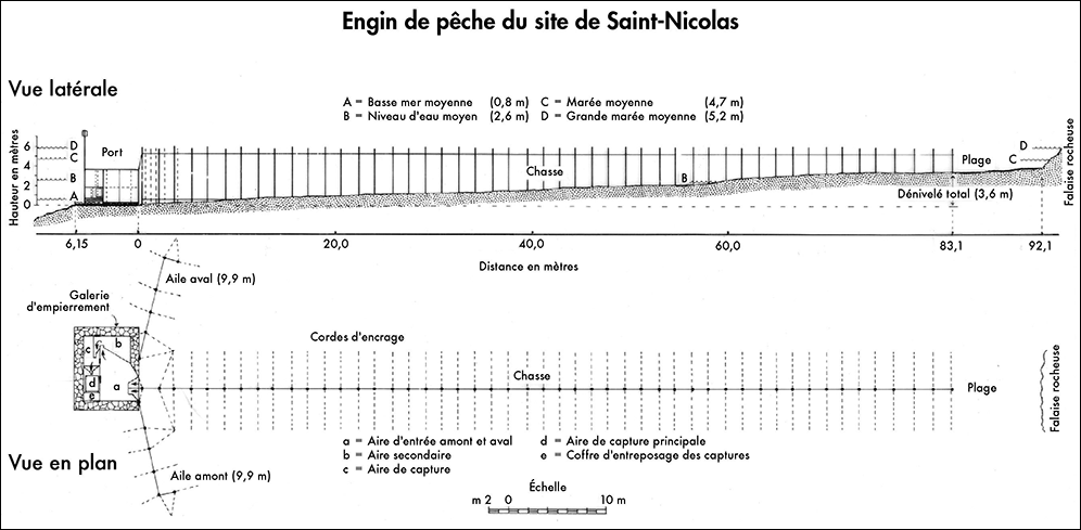

Figure 2: Plan of the Aquarium du Québec’s experimental fishing gear.
Source: Denis Labonté and Yves de Lafontaine.
General operations of the fishery
Each year, the fishing gear is set in the intertidal zone in spring and removed in late fall before the ice season begins. All fishing operations were entrusted to three commercial fishermen: Mr. Fernand Gingras (1971–1988, 1992–1995), Mr. Bernard Côté (1989–1991, 1996–2014) and Mr. Chris Loebsack (2016-today). Recording of the catches is normally done at each low tide—twice a day—between 15 May and 31 October of each year if weather conditions permit access to the gear.
At each visit to the gear, the fisherman identified fish species and counted the number of individuals per species before releasing them alive back to the river through a small door on the rear side of the trap. Data were then recorded on paper forms and transmitted to the Aquarium. Methodological considerations relevant to data interpretation and the potential use of the fishery data are described in Bernier et al. (1996) and de Lafontaine et al. (2002).
Data availability
The database includes catch information for 70 fish species recorded at the different fisheries operated between 1944 and 2019 at Saint-Nicolas and Neuville. The database’s structure makes it possible to quickly trace and associate the catches with fishing activities and with the various characteristics of the activity (for example, the fishing site, methodology, fishermen). From 1971 to 2019, the Aquarium du Québec’s experimental trap fishery was visited 14,966 times and a total of 653,344 fishes were reported (Table 1). From 1944 to 1957, the Neuville fishery was visited 3,537 times and a total of 24,439 fishes were reported (Table 2).
Table 1: Aquarium du Québec’s experimental fishery at Saint-Nicolas
| Year | Fishing start date | Fishing end date | Number of visits to weir | Number of fish | Number of fish species |
|---|---|---|---|---|---|
| 1971 | 1971-05-21 | 1971-11-12 | 310 | 49 721 | 40 |
| 1972 | 1972-05-28 | 1972-10-31 | 304 | 51 345 | 38 |
| 1973 | 1973-05-29 | 1973-10-31 | 297 | 18 804 | 39 |
| 1974 | 1974-06-17 | 1974-10-31 | 264 | 18 034 | 36 |
| 1975 | 1975-05-16 | 1975-10-31 | 320 | 15 726 | 47 |
| 1976 | 1976-05-14 | 1976-10-31 | 327 | 19 516 | 44 |
| 1977 | 1977-05-15 | 1977-10-31 | 326 | 16 011 | 46 |
| 1978 | 1978-05-15 | 1978-10-31 | 327 | 13 043 | 41 |
| 1979 | 1979-05-15 | 1979-10-31 | 329 | 13 956 | 41 |
| 1980 | 1980-06-01 | 1980-10-31 | 296 | 11 009 | 40 |
| 1981 | 1981-05-16 | 1981-10-31 | 326 | 13 328 | 42 |
| 1982 | 1982-05-15 | 1982-10-31 | 328 | 10 545 | 44 |
| 1983 | 1983-05-19 | 1983-10-31 | 320 | 9 467 | 42 |
| 1984 | 1984-05-15 | 1984-10-31 | 328 | 12 993 | 44 |
| 1985 | 1985-05-15 | 1985-10-31 | 328 | 12 385 | 45 |
| 1986 | 1986-05-15 | 1986-10-31 | 325 | 10 191 | 41 |
| 1987 | 1987-05-15 | 1987-10-31 | 329 | 7 913 | 42 |
| 1988 | 1988-05-15 | 1988-10-31 | 326 | 9 423 | 45 |
| 1989 | 1989-05-15 | 1989-10-31 | 297 | 6 132 | 41 |
| 1990 | 1990-05-15 | 1990-11-01 | 325 | 9 034 | 41 |
| 1991 | 1991-05-16 | 1991-10-31 | 324 | 8 741 | 37 |
| 1992 | 1992-05-15 | 1992-10-31 | 328 | 12 232 | 42 |
| 1993 | 1993-05-15 | 1993-10-31 | 328; | 15 630 | 41 |
| 1994 | 1994-05-15 | 1994-10-31 | 328 | 14 087 | 45 |
| 1995 | 1995-05-15 | 1995-10-31 | 329 | 14 957 | 49 |
| 1996 | 1996-05-15 | 1996-10-31 | 323 | 16 101 | 43 |
| 1997 | 1997-05-24 | 1997-11-16 | 317 | 12 368 | 43 |
| 1998 | 1998-05-14 | 1998-10-31 | 328 | 10 271 | 39 |
| 1999 | 1999-05-14 | 1999-10-31 | 330 | 14 794 | 45 |
| 2000 | 2000-05-14 | 2000-10-31 | 327 | 11 549 | 52 |
| 2001 | 2001-05-15 | 2001-10-31 | 320 | 9 950 | 44 |
| 2002 | 2002-05-16 | 2002-10-31 | 321 | 15 909 | 50 |
| 2003 | 2003-05-14 | 2003-10-31 | 330 | 9 926 | 46 |
| 2004 | 2004-05-15 | 2004-10-31 | 325 | 10 179 | 44 |
| 2005 | 2005-05-15 | 2005-10-31 | 312 | 11 055 | 37 |
| 2006 | 2006-05-15 | 2006-10-31 | 312 | 13 976 | 42 |
| 2007 | 2007-05-15 | 2007-10-31 | 325 | 11 909 | 37 |
| 2008 | 2008-05-20 | 2008-10-31 | 306 | 14 365 | 41 |
| 2009 | 2009-05-17 | 2009-10-31 | 311 | 12 905 | 36 |
| 2010 | 2010-06-30 | 2010-10-31 | 236 | 10 450 | 33 |
| 2011 | 2011-06-03 | 2011-10-31 | 275 | 9 634 | 36 |
| 2012 | 2012-05-31 | 2012-10-31 | 296 | 10 123 | 33 |
| 2013 | 2013-05-28 | 2013-10-31 | 302 | 8 573 | 32 |
| 2014 | 2014-05-24 | 2014-10-31 | 310 | 5 885 | 29 |
| 2015 | – | – | – | – | – |
| 2016 | 2016-06-20 | 2016-10-24 | 245 | 2 439 | 40 |
| 2017 | 2017-06-15 | 2017-10-31 | 268 | 10 191 | 41 |
| 2018 | 2018-06-03 | 2018-10-31 | 292 | 11 928 | 41 |
| 2019 | 2019-06-06 | 2019-10-31 | 286 | 14 641 | 43 |
Table 2: Arthur Matte’s commercial fishery at Neuville
| Year | Fishing start date | Fishing end date | Number of visits to weir | Number of fish | Number of fish species |
|---|---|---|---|---|---|
| 1944 | 1944-09-10 | 1944-11-30 | 135 | 2 235 | 11 |
| 1945 | 1945-06-07 | 1945-11-23 | 319 | 4 149 | 19 |
| 1946 | – | – | – | – | – |
| 1947 | 1947-07-18 | 1947-11-24 | 235 | 1 914 | 11 |
| 1948 | 1948-06-03 | 1948-12-03 | 317 | 2 294 | 11 |
| 1949 | 1949-05-06 | 1949-11-23 | 358 | 2 107 | 11 |
| 1950 | 1950-05-10 | 1950-11-24 | 349 | 1 902 | 11 |
| 1951 | 1951-06-01 | 1951-11-19 | 301 | 2 395 | 13 |
| 1952 | – | – | – | – | – |
| 1953 | 1953-05-26 | 1953-12-05 | 318 | 1 481 | 11 |
| 1954 | 1954-06-20 | 1954-12-01 | 266 | 934 | 9 |
| 1955 | 1955-06-01 | 1955-11-19 | 293 | 1 626 | 10 |
| 1956 | 1956-05-14 | 1956-11-19 | 318 | 1 579 | 8 |
| 1957 | 1957-05-10 | 1957-11-25 | 328 | 1 823 | 9 |